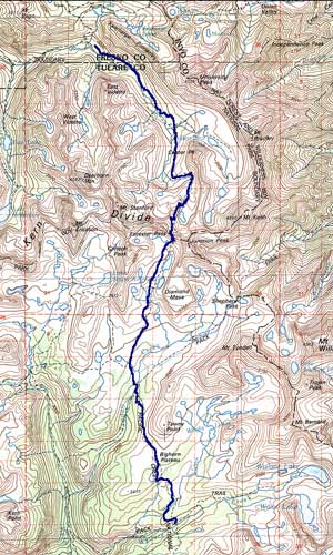
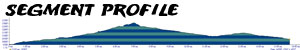
Okay, southbound hikers, it's crunch time. The stretch from Vidette Meadow to the top of Forester Pass gives new meaning to the word, "up." When we first did this stretch we were traveling northbound on a cool, rainy day. All we could think about is, "I'd hate to have to hike up this thing." Having now done the whole trail in both directions, I realize that it's a common downhill sentiment. For some reason, hiking downhill over a long stretch creates the vivid illusion that hiking the same segment in the opposite direction would be far worse. We were prepared for a nightmare climb. Maybe it was because we'd already come this far and our legs and lungs were in fine shape, maybe it was because we split it into two days, maybe it was those unidentified berries we ate, but the climb was nothing like the travail we had anticipated. From Vidette Meadow, the trail winds up Bubbs Creek Canyon at a leisurely slant, never getting too intense. Even past the Center Basin Trail junction (where sits a large, well-used campsite) the incline never gets severe. Steady, but not hard. When you leave the last trees behind, it begins to get worse. The altitude is greater, the trail rockier and the grade progressively steeper. And if you haven't slept since Vidette, the exhaustion grows teeth. The push to the crest of Forester Pass is dramatic, rocky and relentless, but entirely worth it. The views and the accomplishment are unparalleled on the JMT. Look, take pictures, gasp for breath, then start down. From here south to Wallace Creek you hike without drama. The descent is long, uneventful and not as great (Wallace Creek is a thousand feet higher than Vidette Meadow.) Along the way, you pass Tyndall Creek (a tricky ford in early season) and the glorious Bighorn Plateau, where you get your first real glimpse of Mt. Whitney. At last, the trail settles into the pleasant vale where resides Wallace Creek.
Wallace Creek sits at the bottom of a mini-canyon so the initial effort is an uphill one. The trail levels out more or less and snakes towards Big Horn Plateau, which isn't very large in size, but tremendous in views. To scurry past them without lingering would be a mistake...unless you're chased by lightning, as we were in the summer of 2000. Our trek to Forester Pass from the Tyndall Creek was memorable in no small part due to all of that very bad weather we encountered on the way. It seems like a blur because it was. We crested the pass at nine in the morning, having started out on the trail at 6:30 to slip beneath the gathering clouds. The approach to the pass is gentle and long. The pass itself looms like an impregnable wall, fascinating in that it provides no hint as to how a trail actually gets up its face. But it does, slicing through the talus to its final dramatic switchbacks. From then on it's a downhill party, first through granite switchbacks and then into a long sloping descent to Vidette Meadow and its plethora of bears.